How a Spit Grows Across a Bay
Learn how a spit grows across a bay by tracing sediment, waves and currents, then compare its tip and shoreline to describe change with care.
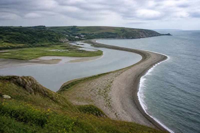
A spit grows across a bay when sediment moves along the shore and gathers where the coastline changes direction. To understand how a spit grows across a bay, trace the material from possible sources to the ridge and its exposed tip. Its shape offers clues, but not a single explanation: waves, tides, river flow and local shelter can combine in different ways.
Sediment sources
Begin with the material forming the strip. A spit may contain sand, gravel, shingle or a mixture. Compare it with nearby beaches and note possible sources such as eroding cliffs, bluffs, river mouths or older deposits. Similar material can suggest a connection, but appearance alone cannot establish where each grain came from.
Do not assume the nearest source is the only one. Sediment may travel along the coast from farther away, while rivers can add material near their mouths. Grain size also matters: coarse pebbles and fine sand respond differently to waves and currents, so the outline of a spit is not enough to reconstruct its sediment route.
Sketch the bay, headlands, river mouths and spit. Mark possible sources as questions to investigate, not as confirmed origins.
Longshore drift
When waves reach a beach at an angle, swash can carry sediment obliquely up the shore while backwash returns it downslope. Repeated movement can transport material along the coast, a process commonly called longshore drift or longshore transport.
The direction and strength of that movement can vary with wave approach, exposure and the shape of the shore. A headland may shelter one stretch while leaving another exposed. Bays can also refract waves, changing their approach as they enter shallower water. An arrow on a map is useful as a working idea, not a settled answer.
Look for several clues before assigning a cause. A beach that narrows on one side of a groyne and broadens on the other may point to interrupted sediment movement, but storms, changing supply and natural variation can also affect the pattern. Consider the wider coast.
Where deposition begins
At a bay entrance, sheltered inlet or the lee of a headland, transported sediment may slow and settle. If material continues to arrive, deposits can extend from the shore as a narrow ridge: the beginning of a spit.
A spit is attached to land at one end and projects into open water, often across part of a bay or estuary. It is more than a long beach: its form records sediment movement alongside the shape of the coast. The water behind it may become more sheltered, but conditions can still change.
Compare the inner side, which may border calmer water, mudflat or salt marsh, with the more exposed outer side. These contrasts can indicate shelter created by the ridge; they do not show that the sheltered area will remain unchanged.
The changing tip
A spit’s seaward end may continue in a fairly straight line, widen, divide into ridges or curve into a hook. Differences in wave approach can redirect sediment near the tip and help bend the ridge back towards land or into the bay.
That is one possible explanation, not a rule. Tidal currents may influence the tip, and river or estuary flow may redirect sediment. Storms can reshape or breach a narrow section; later deposits may alter it again. A hook is evidence of a curved form, not proof of one cause.
Compare the tip with the bay opening and likely wave exposure. Where river flow or strong tidal exchange is prominent, keep those influences in view alongside changing wave approach.
Comparing shoreline images
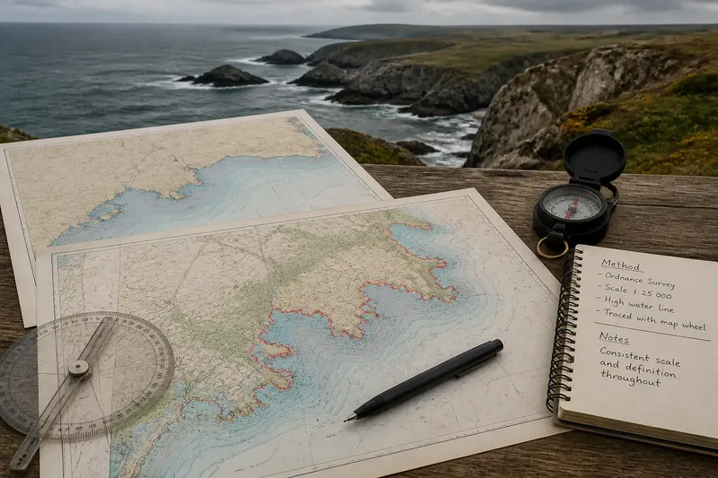
To assess change, compare dated maps or aerial images and align them using recognisable landmarks such as a headland or river mouth. Images taken under different water levels or after different weather may show different apparent shorelines. Seasonal beach changes, storms and image resolution can also complicate comparison.
Trace the attachment point, centreline and tip separately. A change at the tip may coincide with a stable or vulnerable neck, the narrow connection to the mainland. Describing each part avoids assigning one direction of change to the entire landform.
Imagine a bay with a gravel beach, a shallow inlet and a small river entering behind a spit. A later aerial image shows the tip bent farther into the bay. You align the images at the headland, then note the tip’s changed position while checking whether the river channel or inlet has shifted. The result is a careful description: the tip appears to have changed, but the images alone do not identify why.
What changes a spit?
Several influences can affect the sediment available to a spit or the forces acting on it. Use each observation to decide what to examine next, rather than treating one clue as conclusive.
- Possible sediment shortage: Check nearby beaches and exposed deposits for evidence of material supply. If sources appear limited or have changed, describe reduced supply as a possibility; otherwise, keep transport and local deposition in consideration.
- Wave approach: Compare the exposed shore and tip for signs of different wave directions. If the pattern is consistent with a change in approach, consider redirected transport; if not, examine currents and shelter instead.
- Storm effects: Look for an apparent breach, overwash or displaced ridge on dated images. If these features are visible, consider storm reshaping; if they are not, avoid attributing change to a storm without other evidence.
- Tidal or river currents: Check the inlet, river channel and nearby deposits for changes in their form or position. If these have changed alongside the spit, consider their role; if they have not, retain wave action and sediment supply as alternatives.
- Coastal structures: Note groynes, breakwaters and harbour walls, then compare the shoreline on either side. If its form differs beside a structure, investigate whether sediment movement was interrupted; if not, do not assume the structure explains the spit’s shape.
- Image conditions: Check the dates, water levels, weather context and clarity of each image. If these differ substantially, describe the apparent change cautiously; if they are comparable, make a more direct visual comparison while still separating observation from cause.
For a particular coast, local plans and mapping may add context. If site conditions affect access or safety, follow local guidance rather than relying on the landform’s appearance alone.
Questions about spits?
Is a spit the same as a tombolo?
No. A spit projects from the coast into water, while a tombolo is a sediment ridge connecting an island to the mainland or another island. The forms may look related, but their connections differ.
Why does a spit not close every bay?
Waves and currents may continue to move sediment past its end, while tidal flow or a river may maintain an opening. The balance varies by place, so a spit can remain partial rather than sealing a bay.
Does a hooked tip prove waves came from two directions?
No. Differing wave approaches can help curve a tip, but currents, storms and local shelter can also shape it. Treat the hook as a reason to examine conditions, not proof of one process.
Can a spit move as well as grow?
Yes. Sediment may accumulate in one part and be removed from another, so a ridge can extend, retreat, shift or be breached. Comparing separate parts in dated images gives a clearer account than calling the whole feature simply stable or growing.
Describing a spit
Connect three observations in your account: the material present, how it may be transported and where deposition occurs. Then describe the tip and the sheltered side without treating either as a fixed outcome. Separate what the landform shows from what you infer about its cause.
For how a spit grows across a bay, follow the evidence while keeping competing explanations open. Similar outlines can arise from different combinations of sediment supply, wave approach and current, so name the local clues that support your interpretation and the conditions that remain uncertain.